Years ago,
I was working in a middle school in what was called the Resource Department (or
what we called Special Ed when I was in school). These kids were mostly learning disability kids who were in
general classrooms, and my job was to sit in various classes and help these
kids stay on task and re-explain things to them. One social studies project was to do some basic research on
African countries. One of my girls stood in front of the class and read her
first sentence: “The Democratic Republic of the Congo is one of the most
dangerous countries in the world.” And then she paused. At first I thought it
was for dramatic purposes, but I think it was just nerves. But what this girl (whose name I can’t
remember now) will never know is how profound an opening statement is. Of
course, I’m not quite sure this 7th grader knew the magnanimity that
statement holds when she said it.
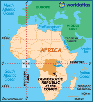
The
Democratic Republic of the Congo is a large country in central Africa,
surrounded by Republic of the Congo, Central African Republic, South Sudan,
Uganda, Rwanda, Burundi, Tanzania, Zambia, Angola, and Angola’s exclave
Cabinda. The Congo River is a major river that runs through this country, also
lending its name to the name of the country. It also shares part of Lake Tanganyika (bordered with
Tanzania) and a small portion – about 17 miles – of the Atlantic Ocean on the
other side of the country. Straddling
the equator, it’s the third largest country in Africa (after Angola and Sudan).

The
earliest residents were thought to have been part of the Bantu migration. One
of the first highlights is the Upemba culture (later to become the Luba Empire
and then the Kingdom of Lunda). The
area they were established was rich in ores, so the development of copper and
iron (as well as their part in the ivory trade) were key to their success. It
helped them to have a strong economy and gave them a lot of wealth. Other
empires such as the Kongo Empire and the Kuba Federation would have major
impacts prior to and during the early days of European involvement. In the late
1870s, the Belgians took over and renamed this area as Congo Free State. It
wasn’t such a good time: many Congolese died from disease and torture by the
Belgians in their efforts to create a thriving rubber industry in concordance
with the new automobile industry.
If you’ve read Joseph Conrad’s Heart
of Darkness (I did a few years ago), it’s set in Congo Free State. In 1908, the Belgians officially called
it a colony, renaming it Belgian Congo. This move was met with a lot of
international disapproval. By the time the 1960s rolled around, Belgian Congo
(like many other African countries at this time) started looking towards
independence. After some upheaval
after independence was granted and a shift in leadership, it rested with Joseph
Mobutu who named it Democratic Republic of the Congo. It later changed to
Republic of Zaïre in 1971 (which is how I learned it growing up). Mobutu was
against communism yet created a one-party system and maintained a system of
embezzlement and corruption that lasted decades. In 1997, the name was changed
back to Democratic Republic of the Congo, and the country had suffered two
civil wars and several conflicts since the late 1990s. These have been some of the deadliest fighting
in history; a study in 2009 estimated around 45,000 are dying every month
(upwards of 5.5 million so far), and a new study estimates that 400,000 women and
girls are raped every year as a result of the prevailing sexual violence.
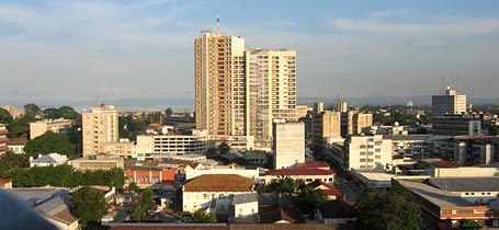
The
capital city is Kinshasa, the city across the Congo River from the capital city
of Republic of the Congo, Brazzaville. However, there isn’t a bridge built yet
to connect the two – people use a ferry to get across. These two capital cities
are the closest capital cities in the world (outside of Rome and Vatican City).
While under Belgian control, it was known as Léopoldville, but when Mabutu took
control, there was a large movement to “Africanize” the names of the cities, so
it was changed to Kinshasa (named after an old fishing village that was located
near the current site). Kinshasa,
incidentally, is the second largest French-speaking cities in the world, after
Paris. It’s also attributed as
being the site of the earliest documented HIV-1 strain in 1959.
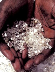
Like
nearby Angola and other African countries, the DR Congo is quite wealthy if you
look at its raw mineral quantities. However, because the country suffers from
so much corruption, it’s not able to mine it effectively. They have more than
30% of the world’s diamond reserves and more than 70% of the world’s coltan
(used for making tantalum capacitors in electronic products). They’re also the largest producer of
cobalt and a large producer of copper as well as some other minor
minerals. Because of the civil
wars and internal conflicts, many foreign companies have pulled their business
operations out of the DR Congo until it becomes safer and its economy more
stable.
About
80-90% of the population consider themselves as followers of Christianity. A smaller number of Congolese follow
Islam (about 10% or so). There is
even a small number of people are members of the Baha’i faith, which was banned
for a time during the 1970s and 1980s.
There are those, as in many other areas of Africa, who embody both
animism and other indigenous religious ideologies with the mainstream
religions. However, many of the mainstream
religious people condemn such practices and are especially harsh in dealing
with things such as witchcraft, etc.
.JPG)
French is
the official language used in the DRC, thanks to the Belgians. It’s also used
as a lingua franca in areas where there are people from different ethnic groups
working together. Of the 242
languages that are actually spoken by citizens of this country, only four have
any special status: Kikongo (Kituba), Lingala, Tshiluba, and Swahili. Dutch was also spoken during the
colonial period since many Belgians also speak Dutch, but it’s not used much
anymore, if any.
The
country has a lot of areas in need of improvement. Much of this is a direct result of the corruption at the
top. Less than half of the country has access to clean water (only 27% in rural
areas), and less than a quarter of the population has functional sanitation.
They have a very high chance of contracting infectious diseases (including both
airborne and waterborne), and their life expectancy is only 54 years old, but they
average only 1 doctor per 10,000 people.
Only 2 out of 3 Congolese are literate (in any language). 71% of the
population lives below the poverty line.
On the plus side, they’re the 7th least obese country in the
world.

Despite
its dire situation, there are some cool things about this country. For instance, they have a small space
program believe it or not. Bonobos and eastern lowland gorillas are only found
here as well. It’s said that locals (and probably more in rural areas) don’t
take too kindly to taking pictures of people – they think when you take a
picture of someone, you’re actually stealing their soul. I always find that
even in the poorest of countries, there is always silver lining somewhere. When
I tell people I’m on the DRC now, I either get blank stares or looks of pity
like I just told them I buried my favorite cat. But I’m convinced it has much
more to offer than being caught up in its horrific statistics regarding war and
corruption. And after I found my recipes, I’m determined there is more out
there.
Up next:
holidays and celebrations