Showing posts with label climate change. Show all posts

Sunday, June 12, 2016

MARSHALL ISLANDS: THE LAND AND THE PEOPLE


I have long criticized how US History classes taught history in the United States. The main complaint is that there is a lot of focus on the American Revolution and the Civil War, which are important no doubt. We should study those events, and to be fair, I do remember studying other battles and historical happenings as well. But as I got older, I started learning more about things in our history we either skimmed past or never talked about at all. And the Marshall Islands are one. 
 
The islands are named after John Marshall, a British explorer and captain of the Scarborough, which visited many of the islands in the South Pacific in 1788. The people who actually live there call their island Jolet Jen Anij, or Gifts From God.  


The Marshall Islands are located in the South Pacific, north of Nauru and east of the Federated States of Micronesia. These islands are roughly halfway between the Hawaiian Islands and Papua New Guinea, although it’s probably a little closer to Papua New Guinea. The climate here is hot and humid with a definite rainy season and a dry season. The problem the Marshall Islands face is two-fold: for a country that is surrounded by water, they need water. Too often, the islands are faced with drought and don’t receive enough freshwater through rainfall. The other side of this is that because of climate change, rising sea levels are threatening the existence of the islands and atolls, much like what Kiribati and the Maldives are going through. 


Much of the earliest records have been lost to history. Alonso de Salazar, a Spanish explorer, was the first European to spot the islands in 1526. A few years later, another Spanish explorer, Álvaro de Saavedra Cerón, visited more of the islands and gave them all Spanish names. However, like what happened with Christopher Columbus, the indigenous peoples had no immunity to the nasty European diseases they brought with them. A couple hundred years later, the British arrived under the guidance of John Charles Marshall and Thomas Gilbert (the namesake of the Gilbert Islands, now part of Kiribati). It wasn’t until a Russian explorer and a French explorer came through a few decades later and named them after Marshall. The Spanish naturally fought to maintain control of the islands, and sovereignty was granted to them, but they quickly sold them off to the Germans as a protectorate. The Germans took control of many other nearby island groups during this time. During WWI, the Japanese took control of many of the islands as a means of taking over German territories. By the beginning of WWII, the Japanese had established schools and airbases, preparing for the onset of war. In 1944, the US captured and occupied the islands. From the end of the war to the late 1950s, the US tested 67 nuclear weapons near the Bikini Atoll in the Marshall Islands. The US compensated the Marshallese nearly $759 million over the period of about 40 years. In 1986, the Marshall Islands finally gained its independence and were officially known as the Republic of the Marshall Islands (or RMI). Since 2008, the Marshall Islands have strongly pushed for climate change talks and have struggled with the effects of this, namely in rising sea levels and drought.  


The largest city in the Marshall Islands, Majuro, serves as its capital with only a little less than 28,000 people (half of the country’s population). The Majuro Atoll consists of several smaller islands, which includes the large communities of Laura and Djarrit. The largest industry here is the service industry. There are a few K-12 schools as well as a couple of colleges/universities. There is some air service between the islands and other countries, and the Majuro Atoll acts as a major port for the area. Because it’s only 10 ft above sea level, it lacks the infrastructure necessary for any large development. 


Because of their environment, it doesn’t lend well for agriculture or natural resources. However, they do have some small commercial farms for coconuts, melons, breadfruit, and tomatoes. They also depend on the service industry as well, mostly in processing fish, some handicrafts, and processing coconuts for copra (the meat) that is used partly for coconut oil. There is some research and experimentation on trying to use coconut oil for energy use, while working to make wind and solar energy readily available and more reliable. Otherwise, the country depends heavily on foreign aid because its imports are greater than its exports; it also utilizes the US dollar as its currency. 
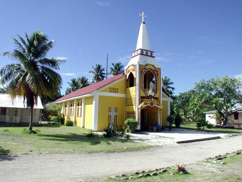
Like other countries who were once governed by European countries, the majority religion is Christianity. There are several denominations present in the islands, the largest being the United Church of Christ. However, Baha’i and Islam are also represented here as well; the first Muslim mosque was built in 2012. 


The vast majority of the people here are of Micronesian descent with a little Japanese mixed in perhaps. Because of their history with the British and the US, English is often spoken and understood, although their official language is Marshallese (locally known as Ebon). There are 34 atolls in the Marshall Islands, and they’re divided into the western atolls (called Ralik) and the eastern atolls (called Ratak). Marshallese has two dialects divided on these same lines. Marshallese is written using Roman letters, although diacritical marks are used on some letters. 


The atolls of the Marshall Islands average about 7 ft above sea level, and one atoll, the Kwajalein Atoll, is the largest coral atoll in the world. There are over 1100 smaller islands and islets that are uninhabited. Although some of the islands’ existence is threatened by rising sea levels, one island in particular no longer exists thanks to the US. The island of Elugelab was blown up in 1952 when US Armed Forces tested a hydrogen bomb on the island. In fact, many of those islands are still uninhabitable due to high amounts of radiation still on the islands, some 60 years later. It’s hard to believe we convinced them this was ok to blow an entire island off the map and poison their people. But, you know. The best we can do is learn about their culture to better understand the people whose islands we took over for a while.

Up next: art and literature

Sunday, May 1, 2016

MALDIVES: THE LAND AND THE PEOPLE


Years ago, I had come across some photos of the Maldives islands. I had never heard of this island group located in the Indian Ocean. Pristine beaches, turquoise seas, sun, palm trees, exquisite resorts. Who wouldn’t be interested in that? For years this small, almost unknown country has been on my bucket list. It would be really expensive to visit though; the flight alone would be over $9000 for the four of us. Even at that, perhaps there’s still a way I can figure out how to “work from home” from the Maldives. For a while at least. 

 
The name Maldives may derive from a number of sources, almost all of them from various Indian languages with the exception of perhaps Arabic and Persian. Many of these meanings are centered around “garland islands” but some older texts refer to it as the “hundred thousand islands.” However, the English word is derived from the Dutch. 


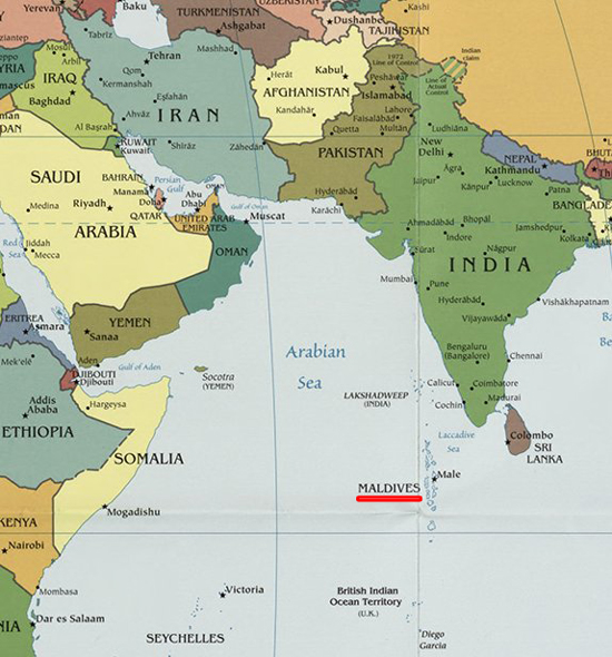
The Maldives Islands are a group of 1190 islands and atolls in the Indian Ocean. The northernmost islands are a little less than 300 miles southwest of the Indian subcontinent. They’re also about 466 miles southwest of Sri Lanka and separated from both India and Sri Lanka by the Laccadive Sea. A little over 1900 miles to the west is Somalia on the Horn of Africa. The southernmost islands are about 750 miles north of the US-owned Diego Garcia Military Base on an atoll that is part of the British Indian Ocean Territory (if you read the Google reviews on this base, it’s full of conspiracy stories about the missing Malaysia Airlines plane being here). Because the Maldives are in a tropical climate, they basically have two seasons: dry season and rainy season. 


The earliest peoples mostly came from the Indian subcontinent and Sri Lanka with a few coming from other areas of Southeast Asia. The Sinhalese arrival signified a change in the culture of the Maldives, and the Dhivehi language was developed during this time as well. The islands went through several religious periods in their history: the earliest peoples practiced a form of Hinduism. Then the first kings promoted Buddhism. By the 12th century, the islands converted to Islam, often attributed as part of the work of a Moroccan traveler by the name of Ibn Batutta. Who exactly he was is up for historical dispute, but his work stuck with the people here. The islands became a stopping point for trade between Africa, the Middle East, Europe and Southeast Asia. By the late 1880s, the British and the Maldives signed a contract agreeing to allow the Maldives become a British protectorate. This contract allowed the British to provide military protection while maintaining local non-interference in exchange for an annual tribute payment. In a disagreement with the government, the three southernmost atolls broke off and started its own country, United Suvadive Republic. However, it rejoined the rest of the country four years later. Two years after this, the island nation gained its full independence from Britain, and later became a republic with a king rather than a sultan. During the 1970s, tourism began to become an economic focus. Several coup attempts during the 1980s finally led to the intervention of the Indian Army. The country was devastated after the 2004 tsunami that resulted from the earthquake. An estimated 108 people died and 57 islands had severe damage to its infrastructure. A series of changes in government and its economic policies occurred during the latter part of the 2000s and is still continuing today.

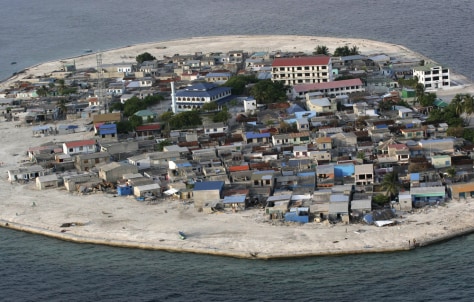
After the tsunami.
The capital city is Malé, located on the southern edge of the Kaafu Atoll. Originally, this was where the kings lived and was called Mahal. After the monarchy was dismantled in 1968, the city was completely rebuilt, and only the Friday Mosque remains as a remnant of that time. Having a population of only 153,000, Malé is also one of the world’s densest cities with about 46,320 people per square mile. (In comparison, my city of Indianapolis has only 457 people per sq mi. New York City comes in at 26,403 people per sq mi.) 


Much of their ancient economy was based on the sea, mostly in the form of cowry shells, coir rope (pronounced “coy-yer”; made from fibers of coconut), and tuna. The cowry shells actually used to serve as a currency of sorts. Today, tourism serves as the country’s largest industry, followed by fishing. The 2004 tsunami took quite a toll on its economy and its government. For the first time, the government levied taxes on goods in 2008. They also implemented certain social programs and a sovereign wealth fund from the tourism dollars. The sovereign wealth fund is essentially a fund intended to purchase land elsewhere in case they have to move due to rising sea levels. 


The dominant religion in the Maldives is Islam, and more specifically, Sunni Islam. Buddhism was once the major religion of the area before the 12th century, and much of the artifacts left over have been housed as museum exhibits. However, a few years ago Islamic extremists launched an attack on Malé’s National Museum and destroyed much of the artifacts in the pre-Islamic areas, leaving only two or three pieces that might be able to be repaired. Today, it’s a fairly conservative country strongly adhering to Islamic law; no other religions are allowed. Freedom of the press is at a minimum, and the government will often side with religious law over secular law. There is absolutely no alcohol, pornography, or homosexuality. 


The official language is Dhivehi, a relative of Sinhalese and part of the Indo-Aryan language family. It’s used several scripts over the past centuries and currently uses the Thaana script, which is read from right to left. This script is pretty much only used for the Dhevahi language and is roughly based on an Arabic script. Because of its history with Britain, English is also widely understood and often used in the government, education, and in commerce. The word “atoll” is said to be the only word in English derived from a Dhevahi word. 


The sea is highly integrated into the Maldivian culture. It’s the lowest country in the world: the highest point is only 7’ 7” above sea level and is 99% water. Because of this, the country is worried about sinking into the sea with the rising sea levels from climate change becoming more and more inevitable. Countries like Kiribati and the Marshall Islands have already felt this impact. In fact, Maldivian officials held a Cabinet meeting underground in 2009 to raise awareness of the growing reality of climate change. All the climate change deniers should speak with the people from these countries. I would like to think it might change their minds, but it probably won’t. So, we better enjoy their culture now. Who knows if the islands will be around in another hundred years?

Up next: art and literature

Sunday, September 13, 2015

KIRIBATI: THE LAND AND THE PEOPLE


There are just some countries that are more known than others. This one gained its independence the year I was born. However, we’re both about as equally known. (Ok, maybe Kiribati has a slight leg up on me.) Regardless, many people—and especially Americans—have barely heard of this country, much less even know what side of the world it is in. Heck, even I had to look up the correct way to pronounce it (it’s “KEER-uh-bahss” if you were wondering). And because of this, it’s one of the few countries that have given me trouble in finding information about its culture and recipes. It’s the second country I have had trouble finding a bread recipe for (Bhutan was the other). On the other hand, essentially everything I learned about this country was new information. 


The name Kiribati is their local pronunciation of the word Gilberts, which is what the British named these islands when they controlled the island group. (The “ti” sounds like “s” in the local language.) Kiribati is located in the South Pacific (or sometimes called Oceanea). It consists of 33 atolls (ring-shaped islands usually made of reef or coral) and reef islands and one raised coral island (the island of Banaba is the only true island in this country). The islands of Western Samoa, American Samoa, Fiji, Tonga are to the south; Tuvalu and Vanuatu are to the southwest; Nauru is to the west; Federated States of Micronesia and Marshall Islands are to the northwest. And the Line Islands (the eastern end of Kiribati) are a little over 1300 miles due south of the Hawaiian Islands. The equator and the International Date Line runs through Kiribati, even though they petitioned to have the date line moved so that the Line Islands can be on the same date as the rest of the country (the Phoenix Islands and the Gilbert Islands ). They enjoy a tropical climate with a rainy season between November and March and a dry season between April and October. Because of the soil makeup, there are limitations on the numbers and kinds of plants and animals that live here. 


Originally, the people living on these islands were Micronesians who had explored eastward and settled here. Other islands in this area (Fiji, Tonga, etc.) also moved (rather, invaded) this area as well. Eventually, they stopped fighting each other and had makeup intermarriage, and after centuries of this, the ethnicity of all of these island groups began to merge. Europeans had major explorations throughout the 17th and 18th centuries, and several of these ships happened to sail past these islands by chance and just stayed. The British eventually took control of these islands and named them the Gilbert Islands after the British captain, Thomas Gilbert. They in turn added in more islands to their holdings, and it became the Gilbert & Ellice Islands as it advanced to crown colony level. (The Ellice Islands became Tuvalu a year before Kiribati gained its independence.) Early during WWII, the Japanese occupied the Tarawa Atoll until the US Marines arrived and told them to get out (more or less, with the only way they knew how to). During the 1950s and 1960s, the US and UK used Christmas Island (also spelled Kiritimati—remember “ti” says “s” in the Gilbertese language) as a testing grounds for nuclear weapons. In July 1979 (a few months before I was born), the Gilbert Islands gained their independence and became known as the Republic of Kiribati to the rest of the world. The people became known as the I-Kiribati. About ten years into their independence, they began to address problems of overcrowding by making people move to other lesser-populated islands. In recent years, the government of Kiribati has been quite vocal about the effects of climate change, especially since two islands were lost in 1999 due to rising sea levels. In fact, they have even started asking other nearby countries to accept their people as refugees due to climate change. Some climate scientists predict that the island nation could be swallowed by the sea within the next 60 years. Other people aren’t so sure on the timeline. It’s certainly a cause for debate. But if you doubt climate change, talk to some of the people who are directly impacted by its effects here. 


The capital is located on the Tarawa Atoll, most widely known for the Battle of Tarawa during WWII, which left over 6000 Japanese and Americans dead at the end of the day. Essentially, the island is divided between South Tarawa and North Tarawa. Causeways have been built to get between the islets. The actual governmental buildings are located on South Tarawa, along with other vital business, financial, and the few higher educational institutions they do have. 


Kiribati’s soil makeup along with the fact that the country is made of reef islands means there are very few natural resources and is thus one of the poorest countries in the world. It’s also one of the least developed. There is an important fishing industry that keeps Kiribati’s economy alive along with some tourism dollars added in there. They also depend of some minor agricultural production as well, mostly in copra, breadfruit, sweet potatoes, taro, and various vegetables. However, the country has to depend quite a bit on developmental assistance from other countries and organizations.


Because Kiribati was controlled by the British for so long, the dominant religion is Roman Catholicism, although the Kiribati Uniting Church maintains a fairly substantial number of practitioners. You’ll also find a number of Protestant faiths as well as Bahá’í and the Church of Jesus Christ of Latter-day Saints. 


English is listed as an official language along with the local dialect called Gilbertese (which is written in Roman letters). English is pretty much only used on the largest island of Tarawa and often used as part of code mixing (mixing the two languages) on the other islands. Gilbertese is interesting to me because it is a verb-object-subject language (in comparison, English and Romance languages are subject-verb-object languages.) There are only a few other languages who fall in this category, namely Malagasy (spoken on Madagascar and Comoros), a few languages in Indonesia, Fijian, and Mayan languages. There are actually Gilbertese speakers not only in Kiribati but also on Fiji, Solomon Islands, and Tuvalu. 


I have a feeling this country is going to be a challenge just because there is limited information on some of the things larger countries have readily available. Like, by now I usually have found at least one or two albums to put in my Spotify playlist. But not so for Kiribati. I have nothing there. Usually, I have been able to find at least one recipe for a bread or cake or pastry or even a mention of this. But not so for Kiribati. (I had to expand out to Micronesia since many I-Kiribati are ethnically Micronesian. And I’m still surprised that for a country that was controlled by the British for so long that there are no bread, cake, or pastry recipes posted online anywhere? I’m still looking, but still… Sheesh.) So, it will certainly be a research challenge, but I’m up for it but have my backups ready.


Up next: art and literature