The sands of Senegal. For millions of Africans across
centuries, the Senegalese coastline is where they took their last footsteps on
the African continent as they were stolen from their ancestral lands and
transported across the ocean in the Transatlantic Slave Trade. Although records
were purposely not well kept as to their origins, it’s estimated that nearly
half of the Africans who were taken came from the Senegambia region (Senegal
and Gambia along with parts of Mali and Guinea-Bissau) and west-central Africa.
Can you imagine what this country (and the entire continent for that matter)
would look like if colonialism didn’t happen?

The country is named after the Senegal River, which serves
as part of its northern border. Its origin is often attributed to a phrase in
the Wolof language, sunu gaal, which means “our canoe,” and has even been used
as a modern phrase of solidarity. It’s also thought that it was spawned out of
a misunderstanding between Wolof fisherman and Portuguese sailors who had
landed there in the 15th century. There are some other theories out
there, but none with quite the colloquial charm as this one, though.
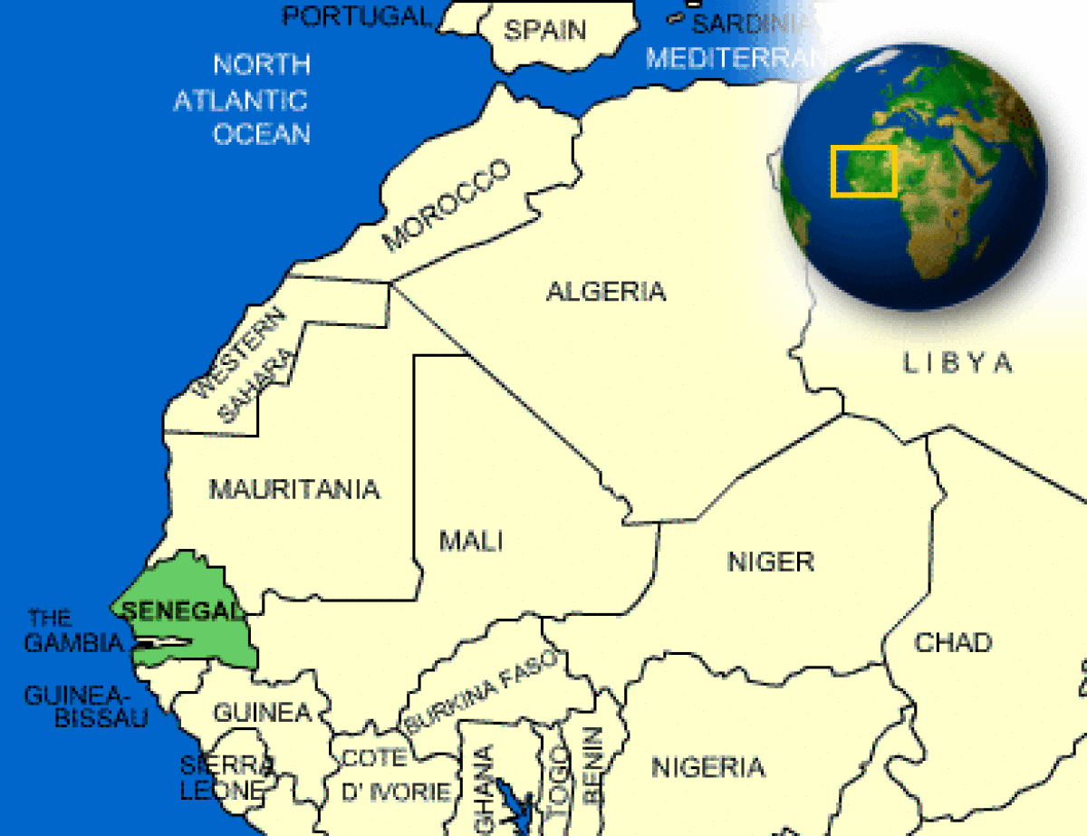
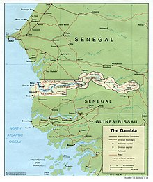
Senegal is located in western Africa along the Atlantic
coast. It completely surrounds The Gambia (which also shares a coastline with
the Atlantic) and shares a border with Mauritania to the north, Mali to the
east, and Guinea and Guinea-Bissau to the south. Cape Verde (oh, sorry: Cabo
Verde) lies off the coast about 350 miles. The country mainly consists of the
sandy plains of the Sahel and low foothills. Senegal’s capital city, Dakar,
lies on the Cap-Vert peninsula, which is the westernmost point in mainland
Africa. It has a tropical climate, characterized by a hot, dry season that sees
plenty of harmattan winds (December-April) contrasted with a rainier season
typically between June-October.
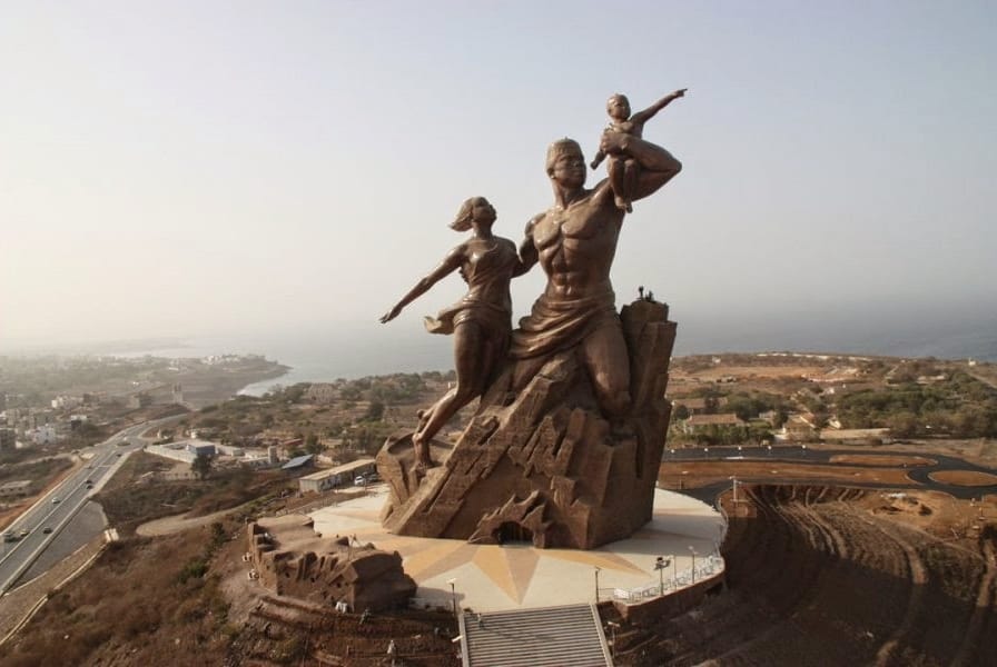 |
| African Renaissance Monument in Dakar |
The area encompassing present-day Senegal has been home to
many ethnic groups since pre-historic times. It was part of several kingdoms
and empires throughout the centuries including the Takrur Kingdom, the Jolof
Empire, and the Ghana Empire. Islam spread through the area as they came into
contact with people from Islam-influenced northern African states. By the
mid-15th century, the Portuguese were the first Europeans to arrive,
quickly followed by the French, the British, and the Dutch. They were just
itching to get in on that human trafficking that was all the rage. (15th
century kids know what I’m talking about.) By the mid-17th century,
France became a dominant player in the slave trade and set up a base point at
Dakar. During the 1850s, Christianity was introduced. As slavery was also abolished
around this time, France began to move farther inland to take over many of the
regions. Of course, the Senegalese were basically like, “Oh, hell no,” and
fought to the teeth over it. French Sudan (which later became Mali) and Senegal
formed the short-lived Mali Federation, only to break up a few months later
(followed by ice cream, crying, and crossing him out of photos); Senegal became
its own independent country in 1960. In 1982, Senegal and Gambia joined
together to form Senegambia, but that broke apart seven years later. The
Casamance region (the part of Senegal that is south of Gambia) has had several
clashes between the government and separatist groups.

Because the capital city of Dakar is located on the Cap-Vert
Peninsula, it makes it not only the westernmost city in Africa, but in the Old
World (Europe, Africa, Asia). Although it was once used as a base for the slave
trade, it is now home to many multinational companies, financial institutions,
as well as the end point for the sort-of-defunct Dakar Rally (a long off-road
challenge from Paris to Dakar; it ended in 2007 due to security reasons in
Mauritania and later moved to South America). Today, there are several colleges
and universities, libraries, museums, sports stadiums, and theatres around the
city.

Some of Senegal’s main industries include chemicals,
artificial fertilizer, cement, food processing, mining, and refining
petroleum. Tourism has become a
driving economic factor, even though there are certain areas that are not
recommended to travel (Casamance, for instance – if you haven’t visited
travel.state.gov, it’s a really good resource for global travel advisories).
Because they’re on the ocean, they also depend on fishing (and stopping other
countries from illegally overfishing their waters). They also farm for cotton
and groundnuts. Senegal is one of the countries that the US Peace Corp sends
volunteers to. I seriously thought about the Peace Corp after I graduated
college. I kind of wish I had.

On the books, Senegal is a secular state. However, roughly
92-94% of the people follow some form of Islam (mostly Sunni and Sufi). A
smaller number of Christians (mostly Roman Catholic with a few Protestant
churches here and there) are also represented. The Serer religion and other
African belief systems are still a part of their society, many times in tandem
with other religions. Other religions include Baha’i, Judaism and Buddhism.

French remains Senegal’s official language, but there’s been
a sort of cultural backlash again using it. Wolof is gaining preference as a
lingua franca since most people speak their own ethnic language. There are a
number of languages that do hold a national legal status, though:
Balanta-Ganja, Wolof, Hassaniya Arabic, Soninke, Jola-Fonyi, Serer, Mandinka,
Pulaar, Mandjak, Noon, and Mankanya. Although Arabic is used in Islamic
schools, it’s not really spoken outside of that environment. There’s also
apparently a Portuguese Creole that is spoken in areas close to Guinea-Bissau
and elsewhere.

So, apparently a few years ago hippos in the Senegal River
mauled several fishermen who were fishing in the river. Quite a few people have
died over the past decade from this. So much so, that it’s impacted the local’s
fishing ability. One guy stated that he’s cheated death-by-hippo a couple of
times. That would probably make me think twice about fishing as a career
choice. But I guess you gotta do what you can to get work. Hippos are very
aggressive, killing machines. In fact, it reminds me of one of John Oliver’s
recent segments on guardianship (you can watch the entire thing, but the part
that mentions hippos starts around 13:32. Oh, and I hope you don’t get offended
at the F bomb. It’s such a versatile word. As I tell my kids, listen past
it).
Up next: art and literature