Showing posts with label French. Show all posts

Sunday, May 15, 2016

MALI: THE LAND AND THE PEOPLE


When I was growing up, there were two main cities that were often used in cartoons to depict “someplace far”: Abu Dhabi and Timbuktu. The first one is in the United Arab Emirates, and the second one is in Mali. It makes me wonder how many Americans knew that. (Besides me, of course.) I won’t get to the UAE for a while, but we get to find out more about what Timbuktu and the land it’s in is all about. 


The name Mali actually means “hippopotamus” in the Malinké and Bamana languages. It also used to be known as French Sudan, but that’s not quite as cool. At least Mali sounds like my niece’s name Molly. 


Mali is a landlocked country located in northeastern Africa, surrounded by Algeria to the north; Niger to the east; Burkina Faso, Côte Ivoire, and Guinea to the south; and Senegal and Mauritania to the west. A large portion of the country lies within the Sahara Desert region, making it a very hot country and without a lot of rainfall. It does have a long, dry season, followed by a short, intense rainy season. 
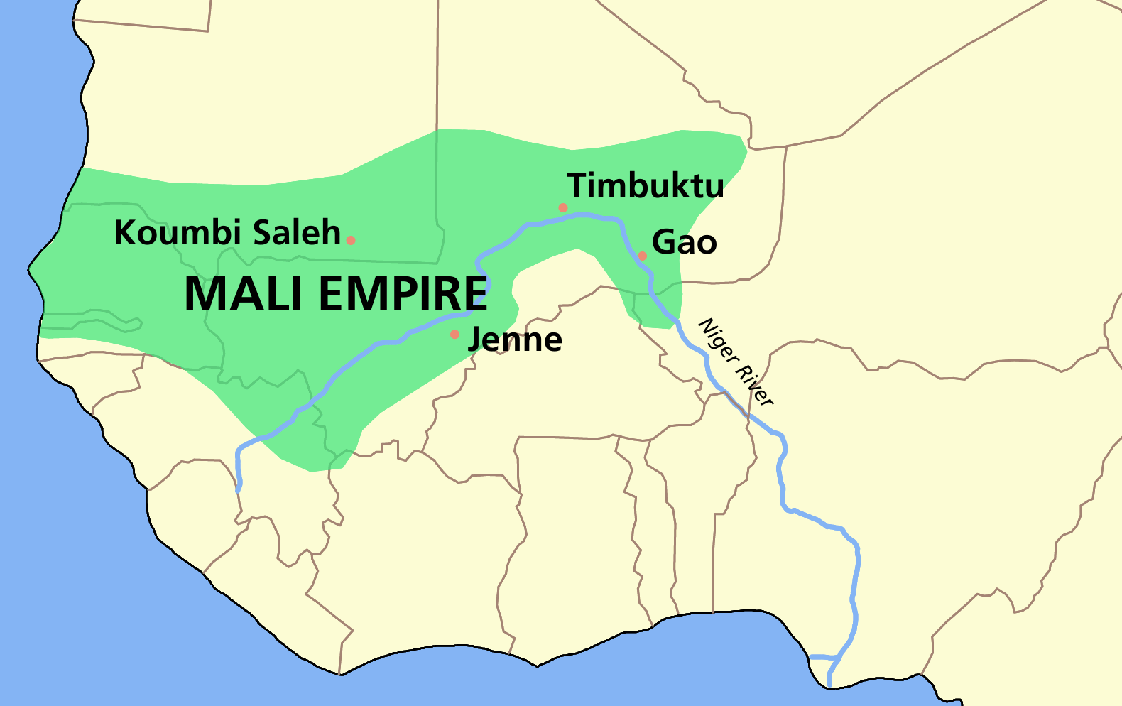


Mali was once part of several great empires. One of the earliest ones in the Ghana Empire (ruled by the Soninke) followed by the Mali Empire. The Mali Empire was centered in the city of Timbuktu, one of the great cities of culture, trade, and Islam. They later were taken over by the Songhai Empire, which subsequently fell to invading Moroccans. After coming under French rule during the late 19th century, it was known as French Sudan. When Senegal united with them in 1959, it became known as the Mali Federation, and they gained their independence from France a year later. It didn’t take long before Senegal broke off to be on its own, and Mali became known as the Republic of Mali. Their first president, Modibo Keïta, quickly established a one-party government. But that didn’t last too long before people got upset about it. Moussa Traoré led a bloodless coup and took over. Although there were some marginal attempts at fixing the economy and establishing democracy, it was countered by banning dissenters and a number of other repressive moves. The country suffered another coup in 1991, and a series of pro-democracy protests across the country led to the March Revolution. Tensions escalated into rioting, resulting in over 300 deaths in four days. Mali had its first democratic elections the following year, and since then has been considered one of the more politically and socially stable countries in Africa today. However, the country made the news again for the Tuareg Rebellion of 2012, one of the early clashes leading to the Northern Mali Conflict. Essentially, the Tuareg rebels fought against the Malian government for independence of the northern region known as Azawad. Historically, this was the home of the nomadic Tuareg tribes. This conflict and instability led to an opening where the Islamic group Ansar Dine entered, whose main goal is to spread sharia law across Mali. 


The capital is Bamako, Mali’s largest city and one of the fastest growing cities in the world. Located on the Niger River, its name means “crocodile tail” in Bambara. Bamako is like many other African cities in that it has benefitted greatly from Chinese investment: many of the infrastructure projects, hospitals, and other needed facilities have been erected through this Chinese-African relationship. Although it’s not uncommon to still find cattle crossing the streets of Bamako, you’ll also find major international company headquarters, museums, music and arts festivals (including a famous photography fest), universities, and a number of parks and landmarks. 


Mali is one of the poorest countries in the world; workers earn an average of only USD$1500 per year. In agreements with the World Bank and the IMF during the late 1980s and early 1990s, Mali underwent changes in the privatization of certain businesses, which did yield some economic growth. The country is part of what’s known as the French Zone, meaning its banks are tied with the French Central Bank. Part of the reason Mali’s economy struggles is that its main economic driver is agriculture (rice, millet, cotton, tobacco), and in an area that is constantly plagued with environmental changes (deforestation, desertification), its crops struggle, too. They have a smaller yet significant energy industry and mining industry (especially in gold, salt, limestone, kaolin, and phosphate). 


Roughly 90% of Malians are Muslim, with the remaining 10% split between Christianity and other indigenous belief systems. Because of the importance of religion being placed in their society, very few are atheist or agnostic (at least for those who admit it). In the past, the Islam practiced in Mali has historically been pretty moderate and tolerant, but the Islamic extremist-led 2012 Northern Mali Conflict has now created a hostile environment for religious minorities.  


While the official language is French, most Malians can speak Bambara and use it as a lingua franca since there are over 40 languages spoken in Mali. Bambara is just one of 12 other languages that are considered national languages. 
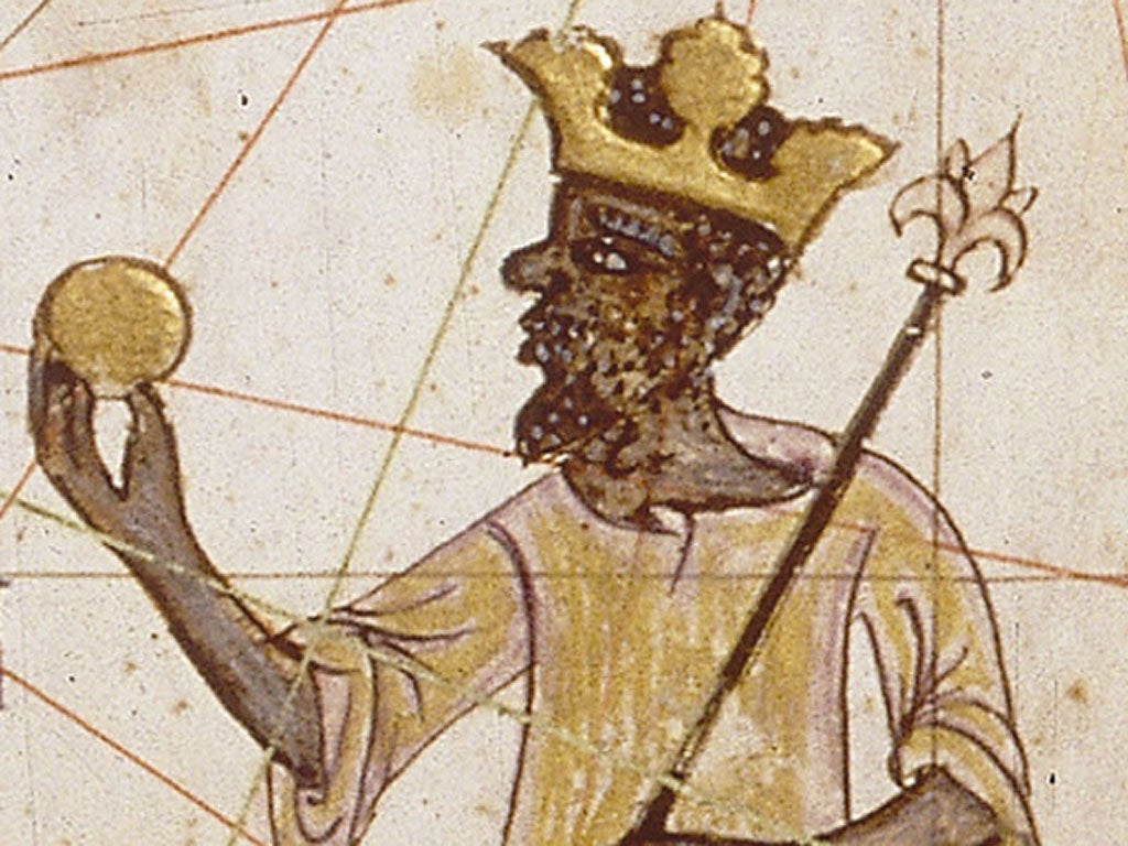


In reading about Mali, I came across Mansa Musa. I read about him years ago, but I had forgotten his name. (He’s actually known by many names, but Mansa Musa is the most common name used by Westerners.) He was a rich leader and devout Muslim, and as he made the traditional pilgrimage, he left so much gold in the cities he stayed in along the way, that it ruined their local economy. When he heard about this, he borrowed gold in each city as he returned to Mali, single-handedly affecting the regional economy in the Mediterranean and northern Africa. He also built a number of mosques, schools, and universities in Mali, bringing in architects, mathematicians, and other scholars from all over to help with the projects and to teach others. There is so much history, so much culture that is tied to this country. It’s hard to believe that at one time it was the center of African culture and run by great empires. And now, less than 10% of the people make more than $2 per day. I can’t wait to find out what this ancient cultural center is all about today.


Up next: art and literature

Sunday, March 20, 2016

MADAGASCAR: THE LAND AND THE PEOPLE


Oh, how my kids loved the Madagascar movies. We have seen it a million times. Not as much as the Cars movies, but certainly enough times to last me for a while. And how true of a representation of Madagascar it is, I don’t know right now. Probably only a small amount, I’m venturing to guess. So, I’m hoping that part of this enlightens me (and perhaps others who read this) on the true Madagascar. 
Baobab trees
Both the people and the language of Madagascar are called Malagasy. And in the Malagasy language, the word for their island is called Madagasikara. However, the word as we know it was brought to us courtesy of Marco Polo, who confused the area and totally mispronounced the name of Mogadishu [Somalia] (which seems strange, because I can’t imagine they look that similar?). 


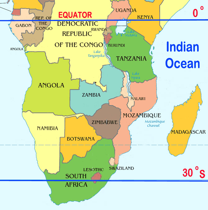
The island of Madagascar is the fourth largest island, located off of the southeast coast of Africa in the Indian Ocean. It’s separated from mainland Africa by the Mozambique Channel, almost directly across from Mozambique itself. In fact, if you look at the shape of the island, it looks like it could almost fit right into Mozambique, which is where it originally was millions of years ago. The Comoros Islands are also in the Mozambique Channel between the northern end of Madagascar and Mozambique. The islands of Reunion and Mauritius are found to the east of Madagascar. To the northeast lies the Seychelles Islands, almost directly east from Kenya and Tanzania. 

Toliara Coral Reef
The eastern side of the island is hit with a lot of rain coming across the Indian Ocean, which supports its rain forests. Trade winds and monsoons help create a hot rainy season (Nov-Apr), contrasting with a cooler dry season (May-Oct, which is when I would definitely go). The central highlands remains slightly cooler. The island also gets hammered with tornados, causing millions of dollars in damage each year. The tropical locale allows the flora and fauna to thrive. The vast majority of the plant and animal life on Madagascar are unique to the island, including its famed lemurs. It’s also home to the Toliara Coral Reef, the third largest coral reef system in the world. 
 
King Radama I
It’s widely believed that the original inhabitants migrated here from Borneo. Arab traders later arrived, followed by Bantu migrants. By several centuries later, Madagascar had become quite the trade hub. The Arabs were the ones who introduced written language. It was essentially the Malagasy language written using Arabic script. The Portuguese were the first Europeans to arrive on the island. The French were next to arrive and quickly established their own trading posts. From the late 1700s, the island became part of the trans-Atlantic slave trade and piracy. The British recognized King Radama I as the King of Madagascar, who abolished their role in the slave trade. The London Missionary Society later established schools and worked on transcribing the Malagasy language into Roman letters instead of the Arabic script. Both France and Britain pressured the local government into the establishment of Christianity. France invaded the country in 1883, and Madagascar ceded the northern section of the island to them. They put in place plantations and additional schools. During WWI, Madagascar fought for the French, but during WWII it was the site of the Battle of Madagascar between the British and the Vichy [French] government. After an uprising in 1958, the island became an autonomous region of France, reaching its full independence in 1960. Madagascar aligned itself with the Eastern Bloq and along with the after effects of the oil crisis and other failed policies, its economic state and living standards fell in the toilet. A change in government in the early 1990s made significant changes to how their government is set up. However, since then, it’s been a cycle of growth and corruption, especially with the political riots in 2010.  

Antananarivo
The capital city, Antananarivo, is located roughly in the middle of the island. Under French control, the city was known as Tananarive, or Tana for short. The name Antananarivo literally means “City of a Thousand,” in reference to a garrison of 1000 soldiers. Although it was originally the capital of the Merina people, today it is a highly multicultural city comprised of all native ethnic groups, European, Indian, and Chinese populations. This city of 1.6 million people is the center of government, media, commerce, finance, and higher education. 

Drying vanilla beans. Yes, vanilla starts out black, not white.
Once Madagascar declared independence and decided to follow a Marxist take on their economy, it practically fell out. There were several failed policies that didn’t work at all. The IMF helped them get on a plan to manage their debt (apparently Peter Francis Geraci was busy). And things have turned around for Madagascar. Eco-tourism is a hot market to be in, although the numbers have declined slightly due to the political unrest. Fishing and forestry are important products Madagascar depends on, along with vanilla, cloves, ylang-ylang, coffee, lychees, and shrimp productions. Nearly half the world’s sapphires come from the island. 


Nearly half of the population still practices indigenous religions, which is highly dependent on ancestral homage. They’re known for their reburial ceremony called famadihana. About half the population also practices Christianity, namely Roman Catholicism. There are a lot of people who also cross over to practice both. Other Christian denominations are also found on the island along with Islam and Hinduism. 


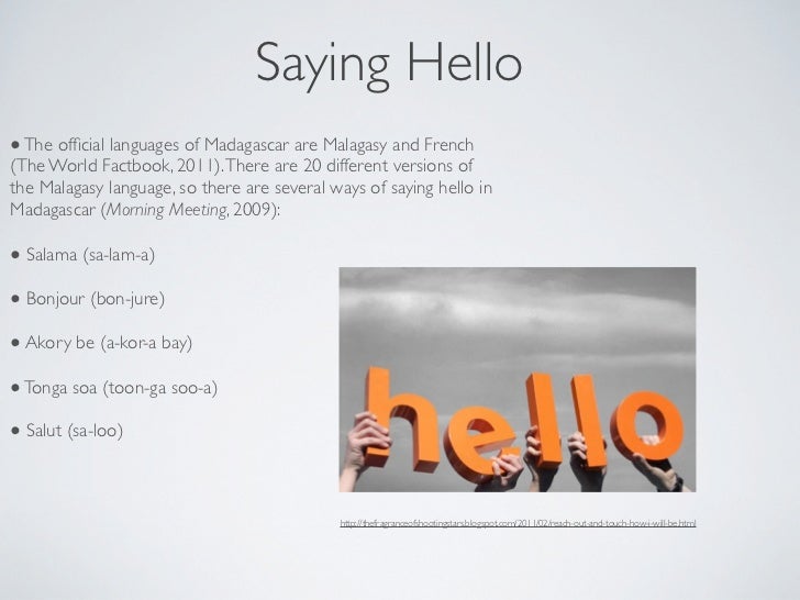
The Malagasy language is in the Malayo-Polynesian family. There are several dialects, but it’s all generally understood. (Like the difference between Texan English and Minnesotan English, I suppose.) Officially, Malagasy and French are listed as the official languages of Madagascar, and English was just removed from the list in 2010. English only made the list because of its historical significance, but seeing how the British really haven’t been involved for quite some time, it’s just time to let that mess go.  


As I combed through several websites about Madagascar, it kind of struck me that Malagasy names can be very long. Like, incredibly long. And that goes for both the names of both people and places. For example, the current president Hery Rajaonarimampianina has a longer surname than any other president/leader of a country. I can only imagine how long it takes for kids to learn how to spell their names. According to a 1999 BBC article I came across, it’s because of two things: 1) the meaning of their names, and 2) originally, people just had one name and only utilized two names when the Europeans introduced it to them. The article cited one of the longest names that belonged to a 19th century king whose full name was King Andrianampoinimerinatompokoindrindra and meant  “the prince who was given birth by Imerina and who is my real lord.” What a mouthful! The only thing that should be a mouthful is their food.

Up next: art and literature

Sunday, October 21, 2012

BENIN: THE LAND AND THE PEOPLE

Tucked away in Western Africa, Benin [pronounced beh-NEEN] is a small country that touches the Atlantic Ocean. Originally called the Kingdom of Dahomey and later called the Republic of Dahomey after their independence (*adding to my list of favorite names), it was later changed to Benin, named after the body of water that lies near it: the Bight of Benin. [A bight – a new term for me – is a geographic term in this sense meaning a large, slightly receding bay.]


Benin is a narrow strip of land that touches the Bight of Benin (Atlantic Ocean) and is bordered by Nigeria, Niger, Burkina Faso, and Togo. The country is hot and dry, with definite rainy seasons and dry seasons. The land is actually somewhat diverse: the coastal areas have many low-lying, sandy plains, forest-covered plateaus to rocky hills and mountains. There are a couple of nature reserves in the northern part of the country, providing great places to be able to see the flora and fauna in the natural habitats.


The Kingdom of Dahomey was known for its military and soldiers – both men’s and women’s corps. For about 300 years, the kingdom was right in the middle of what was known as the “Slave Coast.” And for a while, the Dahomey warriors avoided being part of it, but it did eventually catch up to them as well until it was banned in 1885. By the end of the 1800s, the kingdom had declined, and the French took over the area and controlled it for nearly 60 years until Benin’s independence from France. There was a period in its history where there were several changes in its name as well as its political stance.  In October 1972, Lt. Col. Mathieu Kérékou took over and officially declared Benin as a Marxist country. Scores of teachers and other professionals eventually left the country to escape the regime’s overextended power. In 1989, Kérékou conceded to allow the elections that eventually voted him out, and the name was changed to the Republic of Benin the following year.


Much of Benin’s economy is based on subsistence farming, cotton production and trade. However, there are problems with lower wages for women, child labor, and forced labor. Health care is at a dangerous low. The vast majority of people don’t have access to health care, and there aren’t enough doctors and/or hospitals. Basic sanitation and access to clean drinking water aren’t available in many places, especially true in the rural areas. Risk to infectious diseases are very high: diseases such as hepatitis A, typhoid fever, malaria, yellow fever, meningococcal meningitis, and rabies. Benin is also plagued by high infant and maternal mortality rates with an overall life expectancy of around 60 years old. Benin also has one of the lowest literacy rates in the world, and it’s lower if you’re a female.


Many people in Benin utilize Akan naming traditions, that is, naming children based on the day of the week they were born, birth order, or any special circumstances to which the child was born. One famous example of this would be former Secretary-General of the UN Kofi Annan. (He’s actually from nearby Ghana.) His first name corresponds to Friday, and his middle name of Atta corresponds to him being a twin.

Benin is one of those few countries that has two capitals. The official one is Porto-Novo, but the seat of government is in nearby Cotonou. Because of the French occupation, the French language is the official language, however most people also speak Fon or Yoruba as well as other local and regional African languages. The Fon do make up the majority of ethnic groups in Benin. There are slightly more Christians of various denominations in Benin, followed by those who practice Islam and Vodun (spelled a variety of ways, an animalistic religion that is related to Voodoo in Louisiana and Santería in Cuba).


Benin’s roots as a strong people, the cultural melding of its history, and its geography excites me to delve into its cultural arts, especially its music and cuisine. A country I had only a little pre-knowledge about, my preliminary research has piqued my interest in a country most Americans don’t know where it is, if they’ve even heard of it.  It happens to be a treat for me, since I am cooking and baking on my birthday.

Up next: Holidays and Celebrations

Saturday, September 22, 2012

BELGIUM: THE LAND AND THE PEOPLE


Renowned for its chocolate, beer, and waffles – otherwise known as a perfect meal – Belgium offers much more than that. Located in Western Europe, Belgium lies between Netherlands and France and west of Germany.

It was actually part of the Netherlands until it broke apart and gained independence in 1830. For that reason, Dutch remains the most widely spoken language in Belgium. And actually, Belgium has three official languages: the two main ones are Dutch and French, but there are sizable German-speaking communities as well, prompting German as a third official language, even though less than 1% speak it.

A low-lying country and prone to flooding, Belgium was one of the few countries that were included in the area known as The Low Countries (which included the Netherlands, Belgium, Luxembourg, parts of northern France and western Germany). Several river systems (like the Rhine, the Oise, and Scheldt) and their tributaries meander their way through Belgian fields and countryside.


The name Belgium comes from the ancient Roman name, Gallia Belgica, which pretty much covered the same area. Its capital is Brussels (in French: Bruxelles; in Dutch: Brussel), which also happens to be the de facto capital of the European Union as well as the seat of the French Community and the Flemish Community. Most likely, the name Brussels came from the Old Dutch meaning “home in the marsh” from the words broek (marsh) and sel (home).


Belgium also has several other cities that have become famous over the years. Antwerp is an important seaport in the northern part of Belgium. Legend says that giant used to guard the river Scheldt and charge a toll for crossing the river. For those who refused, he’d cut off a hand and throw it into the river. One day, the valiant Brabo gave the giant a dose of his own medicine and cut off the giant’s hand and threw it into the river. Therefore, the Dutch word for the city Antwerpen prevails (from the words for “hand” and “to throw”). It was host to the 1920 Olympics, but suffered considered damage during WWII a couple decades later.  It’s known as a center of art, especially painting. In fact, Vincent van Gogh lived there for many years. It’s also known for its diamond district, an area of several blocks with many shops for cleaning, cutting, and trading diamonds. Hmm, I may have to make a stop in Antwerp.


History buffs may have heard of the Treaty of Ghent, which was the location of the signing of the treaty that ended the War of 1812 between the United States and England. Today Ghent is the home of Ghent University, Belgium’s first Dutch-speaking university. It’s also the place out of which several culinary dishes grew out of, including waterzooi (which started out as a stew with local fish, but later changed to using chicken). They even have Vegetarian Thursdays, which I think are awesome. It would never catch on in Indianapolis, though, sadly. The best thing in Ghent? A music festival called “I Love Techno” that’s part of the Flanders Expo (no, not Ned Flanders). When the kids are older and moved out, I’m definitely putting that on my calendar. For reals.


Most Belgians enjoy a higher quality of life, the vast majority living in urban settings. And they also enjoy 100% access to clean water and sanitation in both urban and rural settings. About 99% are literate and their healthcare is among the best in Europe (including becoming a popular medical tourism spot). It does happen to be a majority Christian country (and of that 75% are Roman Catholic), although there are sizable communities of other religions, including a large Jewish population in Antwerp. Its multi-cultural environments provide a rich and intricate insight into Europe as a whole. Belgian culture is proving to me to be a fascinating blend of history, art, music, individualism, and perseverance.


Up next: Holidays and Celebrations